Tuesday, October 13, 2009

Denver Day 1

What a challenging forecast today! A wide spread in forecast models was present (mid 60s to lower 50s) and an interesting challenge when it came to the winds.

I checked out the MOS numbers yesterday to see how the NAM and GFS were performing, and it turns out the NAM most for Monday was forecasting a high in the lower 40s while the GFS was forecasting a high in the middle 50s. In the end the high was 51...in the middle. Today the GFS MOS was foreasting a low of 32 and a high of 55, while the NAM was going with a low in the lower 20s and a high of 51. Now, the spread wasn't quite as great on the MOS today as compared to yesterday, but the RAW GFS was still forecasting highs in the mid 60s! It is just amazing how the RAW numbers can be so different than the MOS at one single location.

In the end I went with a high of 55 and a low of 31. Why? Well it all came down to the model performance yesterday and the dewpoint this evening. The NAM did horrible yesterday for its forecast for today. Additionally, the 12Z NAM MOS was saying the high today should have been in the lower 30s....which it obviously wasn't. This immediately made me question the NAM MOS numbers. Additionally, the dewpoint was too low as compared to the current dewpoint temperature, which was leading to a much lower low. However, the GFS did much better than the NAM on its forecast for Monday and the GFS had a correct current dewpoint. Additionally, I did not expect the dewpoint to drop all that much today, but rather hold constant through the night. Thus, my final numbers. Hopefully it works out, but we shall see!

The winds are also a big challenge. The MOS numbers are fairly low around 9 knots while the RAW shows a late increase in wind speed just before dusk to 16 knots. Today around 5/6pm we saw this increase in wind speeds occur. I am not fully sure why...I will have to look into it. But the same thing looks to happen tomorrow, so I leaned towards the higher numbers and went 13 knots. The highest wind speed on Monday was 14 knots as of the 5 pm Climate Report. The high was 51 and the low was 27.

Friday, October 9, 2009

Week 2 After Thoughts and Week 3

Wow, well I was totally wrong about this week. Each system that tried to pull out towards the east lost its energy and dried up, leading to a completely dry week! It did rain Monday, but that wasn't a forecast day so it doesn't count. The GFS was way too wet in the long term last weekend!

And now we move on to Denver where the snow will be flying over the weekend. Luckily we won't have to deal with the snow this first week (at least). Temperatures should warm up nicely for the week. Denver will bring many different challenges compared to Charleston with the primary challenge likely being larger temperature swings. If we can get a strong front to move through the area we could possibly see highs in the 70s followed by lows in the 20s. Anything is possible in Denver. The next week doesn't look like a prime example of this, but the NWS does have highs on Thursday in the 60s with lows near 30. I look forward to the challenge and I hope I can score a little better than in Charleston. I really got punished on my forecast for Thursday. I know why I went 67 for my low and I understand why I ended up going 88 for my high...but I wish I had more time to look at the forecast. Work is a bit more important than a forecast contest, so I only really looked at it for about 10-15 minutes. I should have realized that strong southwesterly flow would lead to stronger heating and the MOS numbers would recognize that well. Oh well! On to Denver!

Saturday, October 3, 2009

First week and thoughts about week 2

Charleston has been a rather dull city so far. The only real challenge was the low Tuesday night because it ended up being a midnight low and the winds....which didn't pan out as high as I had hoped on Friday. Temperatures seemed to follow the 850 mb temperature rules and were very close to MOS, with both the NAM and GFS being very accurate.

However, things should change for week two. Two or three systems have the potential to impact the area. The first will be remnants of Olaf streaming across the south and stalling in the southeast on Tuesday followed by a strong cold front on Wednesday. Thursday we might have a break between systems before a new cold front impacts the area late Friday. (Or at least that is what the models are currently indicating.) This will result in some high scoring opportunities! I wouldn't be surprised to see a winner for this city easily up near -8 or -9 if this much rainfall pans out. I will try and remember to blog on Monday about the possibilities for Tuesday. It will be interesting to see how the moisture from Olaf impacts the area. I see some opportunities to undercut guidance this week and possibility some 6Z lows. Should be a fun week!

Tuesday, September 29, 2009

Day 1 and 2

So yesterday I decided it was best to go a little below MOS Guidance (80F/80F,59F/58F) due to some cold 850 mb temperatures and MOS having difficulty with cold fronts and often going too warm. We will see how that works out, but as for now its ok. I don't see it reaching 80 today.

For tomorrow the 12Z MOS guidance is currently 79F and 53F for both models, which makes the day fairly easy. I am not surprised to see the models drop the high a bit considering 850 mb temps will be even colder tomorrow. No rain is in the forecast and winds should be lighter than today. A deep trough has set up over the eastern US with northwest flow over the area allowing for temperatures to drop easily tonight. MOS has winds coming down to 4-6 mph tonight, which isn't ideal for perfect radiational cooling, but still pretty good. Dewpoints will be in the upper 40s to lower 50s. This seems like a situation where going just above guidance makes sense....but I will have to look at more data to make sure that is the way to go. It's tough to go against such good model consensus. Cloud cover should be minimal tomorrow and tonight.

Sunday, September 27, 2009

One More Time:

Actual numbers for Sunday:

Low Saturday night: 72
High Sunday: 86
Max sustained winds: 24 mph, 21 knots
850 mb temps Sunday: 15C
Forecasted on Sunday (NAM): 16.5C Potential: 88F
Forecasted on Sunday (GFS): 16C Potential: 88F


MOS Forecasts:

GFS 00Z 9/28/09

HIGH Monday: 90 Winds 14 knots
LOW Monday night: 62
HIGH Tuesday: 81 Winds 10 knots
LOW Tuesday night: 52

NAM 00Z 9/28/09

HIGH Monday: 89 Winds 15 knots
LOW Monday night: 63
HIGH Tuesday: 80 Winds 10 knots
LOW Tuesday night: 54

RAW NAM 00Z 9/28/09

HIGH Monday: 89 Lower, Upper Winds 22, 29 knots
LOW Monday night: 61
HIGH Tuesday: 77 Lower, Upper Winds 16, 18 knots
LOW Tuesday night: 52

RAW NAM 18Z 9/27/09

HIGH Monday: 90 Lower, Upper Winds 25, 34 knots
LOW Monday night: 61
HIGH Tuesday: 77 Lower, Upper Winds 18, 19 knots
LOW Tuesday night: 52

Saturday, September 26, 2009

Weather Challenge Begins Soon

I am going to start writing about the Weather Challenge on this website for the foreseeable future. I want to write out some of my thinking without giving my numbers away, so if you are in the challenge please feel free to read this, but don't expect to get actual numbers. For now, I am just going to jot down the MOS numbers for the next couple of days to see some trends and look at actual numbers compared to the forecast numbers. Doing this gives you a little hint as to how well MOS is doing for this forecast location with the current airmass. However, if a different airmass moves into the area the first day of the forecast, doing this can often cause you to react incorrectly. So don't take the trends as a golden rule, it doesn't always work...but it can be handy. The first city is Charleston, SC:

KCHS:

GFS 18Z 9/26/09

LOW Saturday night: 73
HIGH Sunday: 87 Winds 12 knots
LOW Sunday night: 64
HIGH Monday: 90 Winds 14 knots
LOW Monday night: 62


GFS 00Z 9/27/09

HIGH Sunday: 88 Winds 12 knots
LOW Sunday night: 65
HIGH Monday: 90 Winds 14 knots
LOW Monday night: 61


NAM 00Z 9/27/09

HIGH Sunday: 87 Winds 15 knots
LOW Sunday night: 64
HIGH Monday: 89 Winds 12 knots
LOW Monday night: 61

RAW NAM 00Z 9/27/09

HIGH Sunday: 86 Lower, Upper Winds 19, 25 knots
LOW Sunday night: 68
HIGH Monday: 88 Lower, Upper Winds 17, 31 knots
LOW Monday night: 60

Monday, September 14, 2009

Ummmm...

I can't find anything very interesting out there right now. A trough-ridge-trough pattern is set up over North America right now with with some decent heat pumping into the high plains. The high temperature today on the 14th of September was 94 degrees in Philip, SD. Not unprecedented (the record high is 104F), but still hot! Normally when you hear of heat in the 90s in South Dakota you would expect warm or hot temperatures further south within a building ridge in the central US. However that is not the case at the moment as a cut off upper level low has been stuck in the southern Plains for quite a few days now leading to heavy rainfall from Kansas through Texas into the Deep South. Dallas recorded 4-7 inches across the entire city a couple of days ago and Wichita recorded 3-6 inches last Tuesday. This rain has been very beneficial to the drought stricken areas in Texas and generally for much of the southern Plains. Highs have been in the middle to upper 70s in Wichita for the last week! Wonderful temperatures considering it could easily have been much worse if this low had not become cut off.

But this pattern can't last forever, and the cut off low is slowly moving east in some weak westerly flow aloft. Eventually the low will be picked up (maybe not for another 4-5 days in the southeast!) and taken out leaving behind pleasant, slightly warmer, conditions for the southern Plains. A great weekend is in store for much of the central United States!

In other news, the GFS is starting to hint at strong troughs beginning to move into the US once again indicating the start of the fall season. In one run the GFS even had the 522 line at 500 mb all the way down into the Great Lakes in 10 days! It has since backed off, but this is just a sign of the changing of the seasons. Often the GFS likes to bring down strong troughs in the 10-16 day period only to back off as the event comes closer to the present day. The new GFS 00Z is still coming in, so as of now I am not sure what the model is showing in the most recent run.

Wednesday, September 2, 2009

Erika Update

TS Erika keeps reorganizing its center of circulation (COC) and has moved southwest rather than northwest....and is now entering the Caribbean Sea! Convection continues to pulse up and down and a new burst is currently developing over the COC. However, this system is still in a large area of dry air, and as long as that stays true (which it will if this system stays in the Caribbean) then it is going to have a tough time strengthening at all. The winds are now back down to 40 mph, which makes sense considering the structure at this time. Yesterday I could easily understand 60 mph...so I don't fault the NHC for being so strong, there was no reason to think it wasn't, definitely with the Hurricane Hunter data. But now, this system is very raged and doesn't look like it will get its act together anytime soon.

As the storm continues to head west, maybe west-northwest (it has to, right? no more southwest movement) it will move into a dry air mass and possibly over the island of Hispaniola. This island can be a death sentence for many systems, but then again, this system is redeveloping its center regularly, so it could easily redevelop over water just off the coast even if it moves right over the island. Either way, if it moves over the island or just to the north or south, the system will stay weak in the dry environment. It looks like my original thought that a weak system at best would be possible is playing out due to the dry air. Yesterday I kinda gave into the hype. But the weaker the system the more likely it is to continue on a more west heading, instead of pulling northwest and then north and northeast. Right now, if the trough over the east can let up slightly to allow the system to hold together, this storm has a high probability of impacting the US. Making a forecast is very difficult with this storm considering the models have no idea what is going on and Erika seems to have a mind of her own. However, a best guess would be over Hispaniola and then into the Bahamas to stall out....More to come tomorrow when hopefully we will have a better idea what Erika wants to do.

Tuesday, September 1, 2009

Tropical Storm Erika

Tropical Storm Erika has now formed in the Atlantic. The system only needed a closed low level circulation all day long, and once it formed the NHC upgraded to a Tropical Storm at 5 pm. Currently, as of the 8 pm Advisory, the storm has winds sustained at 50 mph, but the convection has increased dramatically in the last few hours, so I wouldn't be surprised to see the winds go up at the next update. The low level circulation is currently outrunning the convection itself, but the last burst was much closer to the center than before. The system is still fighting dry air, and before the dry air can move out..and before the shear off to the northwest weakens, this system will have difficulty strengthening significantly. A weak hurricane could be possible in the next 72 hours if convection continues to pulse up like it has.

The two big questions are if the system can hold on and not pull a Danny...and where is it headed? Currently I think the main issue is the dry air, and this should become less of an issue as the system pulls northwest slowly. The 8pm advisory actually puts Erika as nearly stationary. This is likely because a new circulation is forming closer to the newest burst of convection, which is common in developing cyclones. This would actually cause some retrogression of the circulation back east...but only for a short time. I believe now that Erika has something going for it that the system will hold together and will be something to deal with in the near and long term future.

Currently there is a trough situated through the central Caribbean into the Bahamas, but this should move off to the west and only continue to ventilate Erika...as long as the low level circulation doesn't outrun the convection. If that occurs, then Erika might become completely sheared by this trough and fall apart...but I don't think that is the likely solution at this time. Erika will move northwest to just east of the Bahamas in the next 3-6 days. At this point Erika will likely be a moderate to strong Tropical Storm or weak Hurricane....with the current shear forecast. A boundary sagging along the east coast currently should begin to pull Erika north....however a building ridge of high pressure will come in right behind this boundary to the north holding Erika from pulling out all together....or at least that is what I see happening at this time.

Then the question will be how strong is this ridge? Will it hold Erika south off of the east coast, pull slightly east and then push Erika west towards the US? Or will Erika be strong enough to find any weakness...or develop a weakness, to move north and out to sea? Currently the European model forecasts a pull off to the northeast and out to sea while every other model builds the ridge in and pulls and stalls it out. The GFS never really develops the system that strongly and actually even moves it into the Gulf! There are a wide range of possibilities at this time, but knowing the European's consistency I wouldn't be surprised if it were right. Currently I think it is moving the system too fast, building in the ridge right behind Erika...which would allow it to sneak out. I think Erika won't move northwest fast enough to get to the weakness before the ridge builds in....which could be a bad scenario for the east coast.

PS: Jimena continues to move north towards the Baha and will make landfall along the central coast of the Peninsula as a Major Hurricane. The worst of the weather will miss Cabo, so that's good. The moisture from Jimena will move northeast into the US southwest and connect up with a frontal system moving in from the northwest in the northern and central Rockies and Plains.

Monday, August 31, 2009

94L and Jimena


In the tropical Atlantic the tropical wave named 94L currently has intensified significantly overnight. A large mass of thunderstorms have developed directly over the broad circulation, and now looks destined to be a Tropical Depression by the end of the day. I still think this system is going to have to fight the dry air, but looking upstream to the northwest, where this system will have to go to survive, the moisture increases significantly. Additionally, a stalled out upper low is currently spinning about to the north of the system, and this will help to ventilate it as it passes to the south. So, if this system can fight off the dry air it is experiencing now, I don't see why it can't make it to a named system anymore. 10-20% chance.....bologna. The new name will be Erika.

One thing to point out though, that lingering trough and frontal boundary is still holding off of the eastern coast, and that ridge of high pressure is still supposed to build in. This could lead to three possible solutions. 1) A new low develops and consolidates, weakly (tropical or not tropical) and heads out along the boundary or stalls out...thus interfering with potential Erika as it moves east. 2) The energy is left behind as the ridge builds but does not consolidate, but is instead entrained into potential Erika to make the system stronger as she is pushed back south with the building ridge towards the west. 3) The trough is still just strong enough to leave a weakness to allow Erika to head out to sea.

These three solutions are all possible, and thus make forecasting Erika's track difficult at this time. The CMC right now believes the weakness will be strong enough to pull her north. The Euro, GFS, and HWRF all take Erika west. (The GFDL does not develop the system). Usually for track I like to believe the Euro and CMC in the Atlantic...so I am a bit split. But considering the Euro has been the best this year, I will follow that track. The one issue with the Euro....it doesn't strengthen Erika very much at all, and this could be a limiting factor of the model. The only models to forecast a stronger system are the CMC and HWRF.

Now as for the Pacific, Major Hurricane Jimena is moving north-northwest towards the Baha and is now forecast by the NHC to make landfall a little north of Cabo. This would bring the right side of the storm into the Cabo area, which tends to be the strongest side (more wind, rain, and tornadoes). Not good for the beach resorts! However, right now the track takes it far enough out to sea that the eyewall should miss Cabo directly. Any shift east however could be disastrous. Lessons learned (if the currently forecast track holds true): 1) The GFDL and HWRF were once again too far east...but did better than the Euro and CMC. 2) The models like to lose the moisture once the system makes landfall...which seems highly unlikely. A trough moving in to the northwest US should entrain the moisture from Jimena and lead to heavier rain that expected in the west and northern plains (possible also central plains later).

Saturday, August 29, 2009

Danny Boy Is No More

Danny was absorbed into a new developing low off of the North Carolina coast at around 3 am CT last night. It was very interesting to watch on satellite. Danny's circulation within 6 or 9 hours shot due north towards the North Carolina coast leaving it's convection completely behind. At that time the circulation became elongated, the Hurricane Hunter's found little surface circulation, and Danny was dead. It wasn't too much of a surprise considering the strong upper level trough moving into the area. As usual, a low developed off the coast and began to dominate the environment overpowering Danny. Now there is a rather strong mid-lat cyclone with a lot of tropical energy moving up the east coast. Wind gusts to 50 mph are still going to be possible along the Cape (or at least could have been...the storm is already moving north and away from Mass.) and then in the Canadian Maritimes. Heavy rainfall of 2-4 inches will be common in coastal New England and Canada as well.

Now the attention, at least for the Tropics, turns to invest 94L east of the islands in the central Atlantic and off of the western Mexican coast as a significant tropical system is taking shape. 94L currently doesn't look too impressive and the system continues to have to fight off dry air. Otherwise the environment around 94L isn't all that bad for development. Thus, I could see a weak system developing out of the wave as long as it moves northwest and away from the Caribbean which is extremely dry and has more shear. Odds of a named system...10-20%.

Now as for the western coast of Mexico, a storm that was only designated a depression yesterday evening is now a Hurricane moving towards the northwest. Hurricane Jimena is now a Category 2 hurricane with sustained winds to 105 mph. The current NHC track keeps the storm out to sea as a major hurricane and then turns it slightly further west once it reaches west of the Baha. What concerns me most is that the GFDL and HWRF are bringing this storm into Mexico as a major hurricane rather than keeping it out to sea like all of the other global models. Currently the NHC is sticking with the global models, which makes sense considering the current track record of the HWRF and GFDL this year. Both models, in general, over forecast strengthening and pull the system out to to the north more quickly. However, in this case we have a land mass to the north rather than a Bermuda High. I am not sure how these two models work in this type of environment, so it will be something to watch.

If the system does move north rather than northwest it will be a major disaster in western Mexico as the system will be flooding rains, high storm surge, and very strong winds. Additionally, this type of track would bring a lot of moisture into the southwest US and into the Plains. Track in this case is very important in regard to flooding potential in the US as well.

The next chance of a real close to home system near the US will once again be off the southeast coast as a ridge of high pressure builds in the northeast north of a lingering frontal boundary in 5-10 days. Often when this occurs energy begins to pile up off the coast of Florida to North Carolina. If this energy can consolidate...or a wave (maybe 94L?) can enter the mix in this area, a system can develop. Often these system then pull out towards the northeast, but if the high that has built in is very strong, which the GFS is hinting at, the storm could move west into the southeast.

Friday, August 28, 2009

Obviously I meant...

further west rather than east in my last post...oops.

Right now my original thoughts still look good for Tropical Storm Danny. The storm is fighting the dry air ingested from the upper level low that influenced the system earlier. Additionally, the trough off to the west is causing increased wind shear over the system pushing the most intense convection off to the east. Basically, this storm is doomed. We might see baroclinic strengthening along the coast as the trough advances eastward, but a true tropical system is pretty much done. The low level circulation is exposed with no convection anywhere near the center. If things continue, this storm may even be a depression by the end of the day.

The low will track north just off the NC coast and then head north-northeast into the Canadian Maritimes and that will be that. People in the east will experience heavy rainfall...but it wont be directly related to Danny, instead it will have more to do with tropical moisture from Danny being enhanced by the trough moving east. Basically, this is a non-issue system that if we didn't name storms no one would have any clue it ever occurred.

The next storm may develop further out in the middle Atlantic ocean as a strong tropical wave moves east. This system will have to fight the very dry air in the central Atlantic and I foresee another Ana situation. We might see a name, but a strong system is unlikely. Watch for the next wave following this one as it moves off the African coast and takes advantage of the moistened environment following the wave in the central Atlantic. We could see another situation like Ana and Bill where the second system was stronger. However...the wave moving off the African coast is not quite as impressive as the Bill wave was, so the odds are a little lower we see a major hurricane out of these waves. But hey, just my opinion.

Sunday, August 23, 2009

Possible Additional Tropical Trouble

A new tropical wave is moving westward near the far eastern islands. This wave will move north of the islands towards the southeast coast and combine with some left over energy from the front that just moved off of the eastern coast. An upper level low northwest of this wave is helping to ventilate the system leading to thunderstorm development. However, this upper level low is also creating some wind shear over the wave. Until the low weakens or moves out of the way to the northwest the wave will likely not organize substantially. However, give it 2-4 days and there is a good possibility of a tropical system developing off of the southeastern coast. Many of the global models develop this system...except for the GFS which splits the energy leaving some behind off the southeast coast and the rest pulling out to the northeast. This is a common problem with the GFS, so I wouldn't be surprised to see the energy consolidate in later runs.

The next question will be whether or not this potential system impacts land. Current trends indicate the system might take a track similar to Bill, only slightly further east, thus moving right along the eastern coast or clipping it. As the system develops we will be able to get a better idea. The European model did the best with Bill 10 days out (off by 150 miles) so I am going to lean towards its solution, which is a weak tropical system off of the coast of Florida, moving north and then northeast just off the coast of North Carolina and then off to the Canadian Maritimes. Could be an interesting next week.

Thursday, August 13, 2009

Tropics.....finally.

There are three entities in the tropics that need to be watched at this time. The first is Tropical Depression 2....which is barely a depression at that! The system developed quickly after it moved off the coast of Africa into a decent environment. A few waves had moved off of Africa before TD2 and had moistened up the environment, thus TD2 was able to form and for a few hours could easily have been a tropical storm. However the NHC never upgraded it and it lost all of its convection yesterday afternoon. A small burst of convection occurred during the night so the NHC has not dropped the system. However, it was contemplated last evening....

TD2 is fighting a lot of dry air and has moderate wind shear present over the system. Both of these variables do not add up to a strengthening system, but as long as it holds together there is still the possibility it gets named. At this point I don't see it being named any time soon as TD2 moves west towards the islands. As long as the system stays weak it could move all the way across into the islands in a few days. I think there are two scenarios that could play out with this system: 1) It completely dies and 2) It holds together as a depression, or even weak storm if the convection can refire, for 3-5 days and then track just north of the islands.

The most immediate threat at this point is a burst of convection associated with a positively tilted (I think positive) wave stretching from north of Hispaniola into the eastern Caribbean. Wind shear is in the 15-20 knot range north of Hispaniola where the main burst of convection is located, which isn't great, but not awful either. Sea surface temperatures are not a hindrance. However, the upper level winds are not quite what would you except for a tropical system to be imminently developing. An anti-cyclone is currently progged at 300 mb....which is exactly opposite of what you would need with a tropical system. Unless a high can build over the convection we wont see this storm develop in the next 2 days. However, once this system moves into the Gulf of Mexico all bets are off. An upper level high begins to build in and there is the potential for a system to form from this wave. Luckily it won't have much time to organize before landfall along the coast. I would be amazed if we saw more than a weak TS out of it at the strongest. Just something to watch.

Further out east is going to be the big story down the line. A strong tropical wave has moved off the African coast and every model currently has it forecast to become a tropical system in the next couple of days. The NHC has just upped the risk to HIGH for this wave to develop into a tropical system and I do not see much of a reason for it not to. The one hindrance I have noticed is its large envelope. This is a HUGE wave...often when large waves move off the coast it takes some time for the wave to organize all of that energy into a more concentrated area. The wave has been off the coast for a couple of days now and the system still does not appear to be getting any better organized. I think we will have to wait another 2 days before a depression forms.

But once it does form there is a good chance this is our first big system of the year. Be it Ana, Bill, or Claudette (depending on the two other system in the Atlantic right now) it's name might be the big story of the year. Currently models are forecasting the system to move west across the Atlantic into the Caribbean, then turn north through Hispaniola or Cuba up along the eastern seaboard possibly making landfall on the east coast. The GFS and European both develop the system into a strong tropical system. A building ridge in the Atlantic should allow for the system to easily make it to some landmass....be it just the islands and then out to sea or the USA. The main issue will be the timing of a trough moving off of the eastern United States as the tropical system approaches. Currently the models move it just off the eastern coast....but other runs have had it as far west as New Orleans. So, as always, we don't really know where this system will be headed, but right now if I had to throw out a guess I would say the east coast needs to be ready.

Ok, more to come tomorrow.

Saturday, July 25, 2009

Working the Night Shift

I am working the night shift this week so I am not going to have much time to put together any posts. Hopefully I will get around to it tomorrow. I am very upset with myself today...my forecast was not even close to what it should have been. But this is life, there are going to be bad days. Sadly I saw it happening yesterday and I should have changed my outlook but I couldn't convince myself it was really not going to be the severe weather day I had originally thought. Sometimes you have to go with gut instincts, and yesterday was the day.

I am sure if you are reading this blog you saw the 30% severe weather chance in Ohio the SPC had outlooked. I agreed with them, I didn't see any reason....at first....for it not to happen. But then the MCS held together, kept moving east. The SPC WRF came out and showed the MCS continuing all the way into Ohio, effectively ruining the chance of severe weather in that area by 'working over' the atmosphere and bringing in ample cloud cover. I even said the severe weather for tomorrow (meaning today) could be a complete bust out loud! In the end, this is exactly what happened. No severe weather reports in Ohio at all!!!! This was a time to shine, but it is sometimes very difficult to completely go against what the GFS and NAM are telling you. Lessons learned.

Thursday, July 23, 2009

July 24th, 2009 Severe Weather Outlook

Generally isolated severe weather occurred today in eastern Colorado, Nebraska, western Kansas, eastern North Dakota, and Minnesota. Other spotty storms existed in the east and mid-west, but generally it was a down day for severe weather. However, this should change tomorrow as a potent upper-level system moves into the heart of the midwest. A cold front will dive south, positioning itself in southern Minnesota through central Wisconsin back towards the South Dakota/Nebraska border by midday to midafternoon. Dewpoints ahead of this front are forecast to return to the upper 60s with the bulls eye focused on Iowa leading to CAPE values of 2000-3000 J/kg. A theta-e ridge will stretch from Iowa into central Wisconsin. Helicity will be decent from Iowa through Wisconsin into Michiga with values of 200-300 m^2/s^2. Additionally, strong divergence aloft will occur in Iowa and Wisconsin.

All of these variables should lead to the potential of a more robust severe weather episode from Iowa through northern Michigan, with the greatest risk area beging from Iowa to Wisconsin. A few tornadoes will be possible with high shear values and decent turning of the winds with height. EHI values of up to 2 are forecast by the NAM right along the Iowa/Wisconsin border at 00Z (7 pm). Of course, in additional to the tornado threat, high winds, large hail, lightning, and heavy rain will occur in these areas. Out further west the severe threat will be more isolated, but I would not be surprised to see severe storms develop through Nebraska. Lower dewpoints in eastern Colorado and western Kansas as compared to today should restrict the severe risk in these two areas.


Here is my outlook (it is possible storms could initiate a little further north...but we shall see):


Wednesday, July 22, 2009

East Coast Storm

There is going to be an east coast low forming from tropical energy...that is almost a given now. The question is whether or not the system is extratropical, subtropical, or tropical. The NHC and many of the east coast NWS offices are not jumping on the possibility of a tropical system just yet. However, I have a hunch the NHC will up their outlook area to a moderate before tomorrow is out. Every model shows a storm developing from this energy in the next 12-48 hours, and shear will be at a point that the system could become vertically stacked and warm core, definitely considering the warm water it is currently over. No surface low is currently present in the Bahamas.

The storm will track north-northwest to just off the NC coast and then turn due north and then northeast out to see, possibly impacting New England from Mass. to Maine. A trough moving in from the west may lead to thunderstorm and shower developing in the rest of the northeast as well. This trough and cold front will have more moisture due to the presence of this tropical entity.

The question remains as to whether or not the system will get a name. If it can strengthen quickly it will have a chance, but if a weak low pressure system forms and then it moves off north the system will move into cooler waters and the HPC will have less reason to name it. If the system can get a low pressure focused in 24 hours then I would be surprised if it wasn't declared a depression or named before it moves out to sea.

Surprisingly today a fairly decent area of severe weather developed through Nebraska and western Kansas. I thought things would be a bit less robust, but still nothing crazy today. Primarily hail makers. Tomorrow a new trough will begin to impact the upper mid-west with storms developing in the eastern Dakotas into Minnesota. Additional storms will once again be possible in Nebraska towards southeast Wyoming and northwestern Colorado due to upslope flow. These areas would be the most likely spots for severe weather, but once again I wouldn't expect a huge outbreak. It will probably be on the order of the storms today with an isolated tornado possible (much like today!).

A Look Back

So how did the outlook pan out? Lets compare:


- Obviously a few things were missed including the one long track supercell (well, actually 2-3 storms) which tracked from western Nebraska into western Kansas and the tornadic storms which developed in the front range around midnight. Otherwise, the primary threat area was realized perfectly. A strong MCS developed in eastern Kansas late Monday night bringing widespread wind and hail to the region. Additionally, two tornadoes were reported in the counties surrounding Wichita. The first storm formed well ahead of the MCS in the late afternoon along the warm front west of Wichita and had great structure producing one tornado, hail up to 2 inches, and wind gusts to 70 mph. All in all I would give the outlook a grade of 'B'. In the end the SPC ended up putting some of my area into a moderate risk (the southern half of my 'highest risk' area). The other half of the moderate risk into western Kansas....which did not include the lone supercell in west Kansas...did not pan out at all.
- I think I will try to put together an outlook more often on here sometime before the SPC comes out with their outlook at 1 am. I will try to concentrate on wind and tornadoes since they are the most dangerous 'severe' weather phenomena.
- On to other issues:
- I am still interested in the possibility of a sub-tropical storm forming off the east coast of the United States sometime in the next 2-4 days. Energy is already trying to pile up into the Bahamas and off of the eastern coast of Florida. The tropical wave moving through the Caribbean should also add to the energy in this area as well. Combined with forecast reduction in shear, it could be possible for this to organize into a low pressure system. The big question will be whether or not the system becomes sub-tropical or fully tropical. At this point I could see a sub-tropical storm forming then tracking up the eastern coast and out to sea. This could be our first named storm if the energy can consolidate. Something definitely to watch!
- As for the general US weather state, things are looking fairly calm over the next couple of days. The models continue moving the heavy rainfall in the mid-Mississippi Valley through the Ohio Valley...though flooding risks should be much reduced compared to what occurred today in Arkansas and southern Missouri. Additionally, storms will again develop in the west as the western 'monsoon' has definitely kicked in. Isolated severe storms will be possible, but a widespread severe event doesn't look likely over the next two days. A new system will begin to impact the northern plains and upper mid west, dragging a cold front through the central plains. Right now the models are not going crazy with convection along the front, but things can change. I am sorry about the formatting of this post...for some reason blogspot won't let me put in blank lines...

Sunday, July 19, 2009

Plains Severe Chances on Monday

The SPC has outlooked a very large area of the central plains tomorrow from Nebraska through Oklahoma. ( http://www.spc.noaa.gov/products/outlook/ ) They have even included a 30% hatched area...which I kinda find surprising considering the models were not agreeing with their thinking. Even the new WRF doesn't put major storms going through central Kansas Monday afternoon. I will be very interested in seeing their update at 1 am.

However, just listening to the SPC can really hurt you at times. For instance today when the SPC slowly enlarged their severe area through the day from and area from Texas to Colorado to result in an area from Texas to the Dakotas...which happened to be our original forecast. The SPC has a habit of slowly enlarging areas through the day up to their last afternoon update. I don't fully understand it really.

So what is going to happen tomorrow? Well, looking at the most recent NAM model run, the model has trended further west with many more storm initiating on central Kansas and Nebraska that before. This is much closer to the previous SPC outlook. Two shortwaves are shown moving through the central plains in Nebraska and Kansas with the first shortwave already moving into western Nebraska. This shortwave is the trigger for a lot of the storms today in the west. The wave will move into central and eastern Nebraska/Kansas by midday tomorrow, likely breaking out some early convection. However, this shortwave will move east allowing clearing for more storms in the mid to late afternoon evening as the second shortwave moves out into the central plains.

Decent divergent flow aloft will be in place over the central plains, dewpoints will easily be in the 60s tomorrow afternoon with dewpoints already into the lower 60s in portions of the high plains into west-central Nebraska, and CAPE values will be between 1000 and 2000 in the high to central plains. This should be plenty of energy should get things going in the afternoon as the shortwave moves through. Storms should develop quickly with possible supercells early, but a transition into a linear MCS should not take long. These systems should move south-southeasterly across the central plains. I wouldn't be surprised to see something develop in north-central Kansas or southern Nebraska and move through south-central or southeastern Kansas.

Of course, what I am referring to should be the 'Big Show' for the day. Additional storms will develop from western Texas through the eastern Dakotas into Minnesota, which will likely be severe. The main upper level energy will move through further north, thus triggering storms up north...while greater instability will lead to isolated storms down into western Texas.

So what would an outlook look like if I had to make one....well, here goes nothing (Note, the orange area is a 'greatest risk' area, not really a moderate risk like the SPC does. However, if there was one, I wouldn't be surprised if that's the area. Also, I am not outlooking hail here...):


PS: 97L (Really, 97? How did we get up to that?!) really started to look nice in the central Atlantic today but has quickly lost its convection during the day (diurnal minimum for convection over tropical waters). A refiring of convection could occur tonight, but the system will quickly move into more hostile conditions with strong wind shear taking apart the system. I do not have much confidence that this will be our first named system of the year at this time. However, begin to look off the eastern seaboard in the next week. A 'rabbit out of the hat' (Bastadi's term) system might be in the cards....

Tuesday, July 14, 2009

Brief Tropical and Wichita Update

As for the tropics, things are still very dead in the Atlantic. A large plume of African dust is currently stretching from the Caribbean to the African coast...so little development in this area can be expected anytime soon. However one possibility will be along the eastern coast of the United States from the weekend into next week. A strong trough will push into the east, followed by a building ridge in the northeast. Sometimes energy can get trapped off the southeast coast when this occurs underneath the building ridge. This trapped energy can slowly develop resulting in a tropical system. It will be an area to watch, but the chances are still low.

As for Wichita we will finally get some 'cooler' air into the area. Actually, following today (the current temperature is 105F!) we should see a few days over the next week and a half of highs in the upper 80s with lower dewpoints! Additionally, the rain chances will come back into the picture as northwest flow sets up over the central plains. The upper-level environment will be very supportive of strong MCSs moving across the area, the only question will be how much moisture will be present. If dewpoints get back into the upper 70s or low 80s there could be some significant events ahead of us. But this is all conditional....along with the tropical possibilities in the week ahead.

PS: Finally finished editing my thesis...so I should be able to keep up with this blog more often now.

Monday, July 6, 2009

Tropical Update

Nothing is going on.

Thanks for reading.


Ok, seriously, nothing really is going on. But the new 12Z GFS does indicate that the Cape Verde season is around the corner (not that we didn't know that considering climatology). 9 days out (a hell of a long way out) the GFS brings a wave off the west coast of Africa and has a hurricane in the Bahamas on Day 16. Will there be a hurricane in the Bahamas on Day 16? I doubt it. But then again...who knows. Models are notoriously bad more than 3-4 days out...and often just awful. To believe a model 9 days out...or 16 days out...is rather ridiculous. So, what we can take from this is that the model is starting to hint that the Cape Verde season is about to get started. The majority of strong hurricanes come from Cape Verde western propagating tropical waves. Thus, the hurricane season might be about to heat up...

BUT: This year is an El Nino year...or at least we are moving into a weak El Nino at the moment. El Nino years lead to increased shear across the tropical North Atlantic and usually start hot in May/June/July and die starting in August when the shear increases. We are already into early July and we have not had a named storm yet this year. What does this mean? I wouldn't be surprised if this is a 5-6 named storm year. I thought if we got a few names in May/June/July we could reach 10, but if we don't get 2-3 before the end of July...say goodbye to 10 named storms.

Here is what I am thinking: 1 in July (possibly)...1 or 2 in August...2 in September....1 in October....done. Now it is on the record. Lets see how wrong I am....c'est la vie. (Can you feel the confidence!?)

Friday, July 3, 2009

Rewarding

I have to say, one of the most rewarding things to do is to put together a forecast and then have the SPC outlook the exact same area you outlooked 4-5 hours earlier. I can't show you my (and a coworkers) forecast today because, well, you would have to pay for it. But the outlooked severe area ended up being exactly what the SPC put up just now. It might not pan out exactly how we forecasted, but it shows we know what we are doing. So, if you want to know what I am thinking for tomorrow and Saturday...just check out the SPC.

Thursday, July 2, 2009

Well there was a MCS....

But not quite what I was thinking. The MCS developed in the evening, just as my original prediction had said, in western Nebraska (and eastern Wyoming) and moved east-southeast through southern Nebraska and northern Kansas before pulling south across central Kansas towards northeastern Oklahoma. So, the system did develop and tracked pretty much where I was thinking (except I was thinking more up near Kansas City than northeastern Oklahoma). However, the system did not have any severe weather associated with it except for a brief period back in Wyoming and western Nebraska.


Why did it not have the severe weather associated it? Because of a front sitting in the central Gulf of Mexico. As Bernie Rayno said on Point-Counter-Point yesterday, the dewpoints were just not high enough because the inflow from the Gulf was being cut off. Which is exactly what happened. Instead of low 60s dewpoints in Nebraska they were in the mid to upper 50s. This is not the environment you would expect for a wind event. Actually, 70 degree dewpoints are much more supportive. Thus, the system wasn't severe, but it was there.


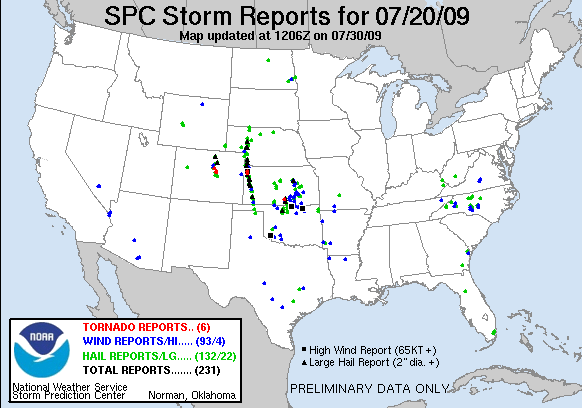
And the system yesterday will help increase the potential for the coming weekend as a front shifts south through the plains. Already in areas where storms have developed the last few days, storms have redeveloped (in Montana, Wyoming, and South Dakota). These storms will once again produce an MCS which will move through Nebraska likely into Kansas. Will the system be severe? Not quite likely yet. However Friday into Saturday looks like a much better environment with dewpoints slowly rising.

Also, check out this map of rainfall from just yesterday in Florida. Yes, 6+ inches will easily be reached...and that was only from one 24 hour period.

Tuesday, June 30, 2009

MCS...YES

It always feels nice when the SPC changes their forecast to your own forecast....and that is what happened last night. I am sure the SPC knew the possibility of an MCS was there, but they didn't want to go out on a limb and forecast a slight risk for a certain location (which would likely have been further south 3 days out) when the actual location of the event might have been somewhere else. At this point though, everything seems to be in line for a decent MCS moving through the central plains Wednesday evening and night. High wind gusts and large hail will be the primary threats from this system, with an isolated tornado threat possible in the Northern High Plains in the late afternoon and evening from western Nebraska to the western Dakotas.

I didn't really get into the threat of severe weather in the northeast last night, and I guess I should have considering the storms that have developed up in that region today. Decent lapse rates and dewpoints in combination with a substantial upper level low are resulting in the storms today. The SPC has also outlooked this area for storms tomorrow, but I really haven't looked that much into it. Lets be honest, I live in the Plains, so this blog will center on the Plains.

MCS development will be likely Wednesday into the weekend. It is possible Thursday is a 'slow' severe weather day without a strong MCS but the MCS train will likely start up once again on Friday. Reminder: Once one Derecho or strong MCS develops in a certain environment it is very likely for a second one to develop the next day (or sooner) should the environment not change. In this case, the first Wednesday night event will be associated with a shortwave moving through the region...Thursday will lack this same substantial shortwave. But moisture will increase into the weekend, so the severe weather threat will likely once again increase.

Now it is time to go golfing and then come home and work on my thesis some more. I am getting there and have 5 days to get it done. I was invited to go bowling tonight...but I think working on my thesis would be the better, more responsible thing to do considering the time crunch!

Monday, June 29, 2009

MCS in the Making?

Tomorrow doesn't look all that impressive on the severe weather front...tropical front...except maybe on the front through Florida. However, not impressive in a severe weather sense, but more the fact that Florida is going to see A LOT of rain over the next 4 days. A front is stalling out over the center of the state and I wouldn't be surprise, considering the tropical wave which is moving into the gulf, to see areas with 6+ inch totals over the next few days. But we shall wait and see.

Anywho, this entry is really about the chances for a nocturnal MCS with the threat of wind across the central plains. The models have sure trended down with the threat over the last 24 hours, now with the NAM moving the system a little north through Nebraska and maybe northern Kansas, and not bombing it out like it did yesterday. The GFS and NAM are now very consistent with the placement of the system and strength, which gives me a bit more confidence.

Currently both models are indicating a surface low developing in western Kansas leading to southerly flow into the Central Plains. This southerly flow will increase dewpoints across northern Kansas and Nebraska back up into the middle 60s (a little higher than the 52 dewpoint we experienced today in Wichita!). At 500 mb the flow will be out of the northwest (thus called Northwest Flow....) with a shortwave moving into the central plains Wednesday afternoon. This shortwave and increasing low level jet into the evening will lead to thunderstorm development across western Nebraska along the warm front. The low level jet will be nearly due south in the early evening as the MCS begins to evolve in Nebraska but will turn out of the southwest as the system moves towards the east into the Omaha and Kansas City areas. This will allow the MCS to continue its eastward propegation...and if the system can stay surface based, could have some decent wind threat late into the night and early morning.

Currently the SPC has a 5% chance of thunderstorms for this area....which makes me wonder if I am just crazy. But the conditions look decent for a good thunderstorm complex to develop and treck across the plains...so I am not going to back down...yet. I will be very interested in seeing the day 2 forecast that is issued later tonight.

ADDITION:
And here is the outlook for Day 2 (Wednesday):

Sunday, June 28, 2009

A Relative Calm

The next couple of days can be expected to be relatively calm compared to the storms which impacted the country from the Dakotas to the Gulf Coast the last three days. Storms will continue in Florida through Texas and up the High Plains with strong wind gusts and large hail the threats. No real high risk of a major wind event or tornado threat is expected. However, models seem to be trending towards the risk of a large MCS on day 3...or Wednesday. Both the GFS and NAM develop this system, with the NAM being much stronger than the GFS. It will be something to watch and I will go into more detail tomorrow night if the models are still showing it. Currently the NAM has a shortwave at 500 mb traversing from the High Plains through Kansas Wednesday night in northwest flow. Dewpoints should be back into the mid 60s to lower 70s with highs in the mid 90s across much of Kansas.

Thesis Writing and Hot Weather

I haven't been updating this for a long time, but I thought I might as well start it up again. This first update will be brief and I will start getting into more of a weather blog once again next time (hopefully tomorrow after work).

I have been working on re-writing my thesis now for a month and a half...and I tell you, it is not easy. The reviewers have asked for many small...and large...changes to the manuscript and it takes a lot of time. But I am getting there. I hope to be close to done by the 3rd or 4th of July and maybe, just maybe, you will get to read my thesis in Weather and Forecasting.

As for the recent weather, there is only one word that describes it: HOT! We went golfing a few days ago at 2:15 in the afternoon on a day when the high was 98F and the dewpoint was in the lower 70s. And we played as a group of 5.....not smart. The large group resulted in us taking 3 hours to play 9 holes! In 100 degree heat index weather. Definitely not the smartest thing I have done. But I shall learn from that mistake and play in the late afternoons on these really hot days in the future.

The storm chasing year has been nice to me. Saw two tornadoes...and could easily have seen 6 more if Shaina and I didn't decide to call off the chase one day and go to a nature preserve. But that's how it goes. There will be more opportunities next year.

I will update either later tonight before I go to bed with a weather discussion or tomorrow evening. As for now, back to editing the thesis.