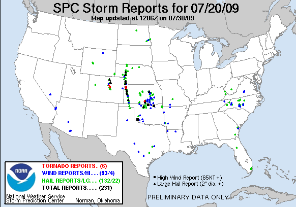

- Obviously a few things were missed including the one long track supercell (well, actually 2-3 storms) which tracked from western Nebraska into western Kansas and the tornadic storms which developed in the front range around midnight. Otherwise, the primary threat area was realized perfectly. A strong MCS developed in eastern Kansas late Monday night bringing widespread wind and hail to the region. Additionally, two tornadoes were reported in the counties surrounding Wichita. The first storm formed well ahead of the MCS in the late afternoon along the warm front west of Wichita and had great structure producing one tornado, hail up to 2 inches, and wind gusts to 70 mph. All in all I would give the outlook a grade of 'B'. In the end the SPC ended up putting some of my area into a moderate risk (the southern half of my 'highest risk' area). The other half of the moderate risk into western Kansas....which did not include the lone supercell in west Kansas...did not pan out at all.
- I think I will try to put together an outlook more often on here sometime before the SPC comes out with their outlook at 1 am. I will try to concentrate on wind and tornadoes since they are the most dangerous 'severe' weather phenomena.
- On to other issues:
- I am still interested in the possibility of a sub-tropical storm forming off the east coast of the United States sometime in the next 2-4 days. Energy is already trying to pile up into the Bahamas and off of the eastern coast of Florida. The tropical wave moving through the Caribbean should also add to the energy in this area as well. Combined with forecast reduction in shear, it could be possible for this to organize into a low pressure system. The big question will be whether or not the system becomes sub-tropical or fully tropical. At this point I could see a sub-tropical storm forming then tracking up the eastern coast and out to sea. This could be our first named storm if the energy can consolidate. Something definitely to watch!
- As for the general US weather state, things are looking fairly calm over the next couple of days. The models continue moving the heavy rainfall in the mid-Mississippi Valley through the Ohio Valley...though flooding risks should be much reduced compared to what occurred today in Arkansas and southern Missouri. Additionally, storms will again develop in the west as the western 'monsoon' has definitely kicked in. Isolated severe storms will be possible, but a widespread severe event doesn't look likely over the next two days. A new system will begin to impact the northern plains and upper mid west, dragging a cold front through the central plains. Right now the models are not going crazy with convection along the front, but things can change. I am sorry about the formatting of this post...for some reason blogspot won't let me put in blank lines...

No comments:
Post a Comment