Saturday, July 25, 2009

Working the Night Shift

I am working the night shift this week so I am not going to have much time to put together any posts. Hopefully I will get around to it tomorrow. I am very upset with myself today...my forecast was not even close to what it should have been. But this is life, there are going to be bad days. Sadly I saw it happening yesterday and I should have changed my outlook but I couldn't convince myself it was really not going to be the severe weather day I had originally thought. Sometimes you have to go with gut instincts, and yesterday was the day.

I am sure if you are reading this blog you saw the 30% severe weather chance in Ohio the SPC had outlooked. I agreed with them, I didn't see any reason....at first....for it not to happen. But then the MCS held together, kept moving east. The SPC WRF came out and showed the MCS continuing all the way into Ohio, effectively ruining the chance of severe weather in that area by 'working over' the atmosphere and bringing in ample cloud cover. I even said the severe weather for tomorrow (meaning today) could be a complete bust out loud! In the end, this is exactly what happened. No severe weather reports in Ohio at all!!!! This was a time to shine, but it is sometimes very difficult to completely go against what the GFS and NAM are telling you. Lessons learned.

Thursday, July 23, 2009

July 24th, 2009 Severe Weather Outlook

Generally isolated severe weather occurred today in eastern Colorado, Nebraska, western Kansas, eastern North Dakota, and Minnesota. Other spotty storms existed in the east and mid-west, but generally it was a down day for severe weather. However, this should change tomorrow as a potent upper-level system moves into the heart of the midwest. A cold front will dive south, positioning itself in southern Minnesota through central Wisconsin back towards the South Dakota/Nebraska border by midday to midafternoon. Dewpoints ahead of this front are forecast to return to the upper 60s with the bulls eye focused on Iowa leading to CAPE values of 2000-3000 J/kg. A theta-e ridge will stretch from Iowa into central Wisconsin. Helicity will be decent from Iowa through Wisconsin into Michiga with values of 200-300 m^2/s^2. Additionally, strong divergence aloft will occur in Iowa and Wisconsin.

All of these variables should lead to the potential of a more robust severe weather episode from Iowa through northern Michigan, with the greatest risk area beging from Iowa to Wisconsin. A few tornadoes will be possible with high shear values and decent turning of the winds with height. EHI values of up to 2 are forecast by the NAM right along the Iowa/Wisconsin border at 00Z (7 pm). Of course, in additional to the tornado threat, high winds, large hail, lightning, and heavy rain will occur in these areas. Out further west the severe threat will be more isolated, but I would not be surprised to see severe storms develop through Nebraska. Lower dewpoints in eastern Colorado and western Kansas as compared to today should restrict the severe risk in these two areas.


Here is my outlook (it is possible storms could initiate a little further north...but we shall see):


Wednesday, July 22, 2009

East Coast Storm

There is going to be an east coast low forming from tropical energy...that is almost a given now. The question is whether or not the system is extratropical, subtropical, or tropical. The NHC and many of the east coast NWS offices are not jumping on the possibility of a tropical system just yet. However, I have a hunch the NHC will up their outlook area to a moderate before tomorrow is out. Every model shows a storm developing from this energy in the next 12-48 hours, and shear will be at a point that the system could become vertically stacked and warm core, definitely considering the warm water it is currently over. No surface low is currently present in the Bahamas.

The storm will track north-northwest to just off the NC coast and then turn due north and then northeast out to see, possibly impacting New England from Mass. to Maine. A trough moving in from the west may lead to thunderstorm and shower developing in the rest of the northeast as well. This trough and cold front will have more moisture due to the presence of this tropical entity.

The question remains as to whether or not the system will get a name. If it can strengthen quickly it will have a chance, but if a weak low pressure system forms and then it moves off north the system will move into cooler waters and the HPC will have less reason to name it. If the system can get a low pressure focused in 24 hours then I would be surprised if it wasn't declared a depression or named before it moves out to sea.

Surprisingly today a fairly decent area of severe weather developed through Nebraska and western Kansas. I thought things would be a bit less robust, but still nothing crazy today. Primarily hail makers. Tomorrow a new trough will begin to impact the upper mid-west with storms developing in the eastern Dakotas into Minnesota. Additional storms will once again be possible in Nebraska towards southeast Wyoming and northwestern Colorado due to upslope flow. These areas would be the most likely spots for severe weather, but once again I wouldn't expect a huge outbreak. It will probably be on the order of the storms today with an isolated tornado possible (much like today!).

A Look Back

So how did the outlook pan out? Lets compare:


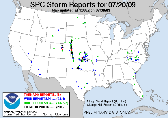
- Obviously a few things were missed including the one long track supercell (well, actually 2-3 storms) which tracked from western Nebraska into western Kansas and the tornadic storms which developed in the front range around midnight. Otherwise, the primary threat area was realized perfectly. A strong MCS developed in eastern Kansas late Monday night bringing widespread wind and hail to the region. Additionally, two tornadoes were reported in the counties surrounding Wichita. The first storm formed well ahead of the MCS in the late afternoon along the warm front west of Wichita and had great structure producing one tornado, hail up to 2 inches, and wind gusts to 70 mph. All in all I would give the outlook a grade of 'B'. In the end the SPC ended up putting some of my area into a moderate risk (the southern half of my 'highest risk' area). The other half of the moderate risk into western Kansas....which did not include the lone supercell in west Kansas...did not pan out at all.
- I think I will try to put together an outlook more often on here sometime before the SPC comes out with their outlook at 1 am. I will try to concentrate on wind and tornadoes since they are the most dangerous 'severe' weather phenomena.
- On to other issues:
- I am still interested in the possibility of a sub-tropical storm forming off the east coast of the United States sometime in the next 2-4 days. Energy is already trying to pile up into the Bahamas and off of the eastern coast of Florida. The tropical wave moving through the Caribbean should also add to the energy in this area as well. Combined with forecast reduction in shear, it could be possible for this to organize into a low pressure system. The big question will be whether or not the system becomes sub-tropical or fully tropical. At this point I could see a sub-tropical storm forming then tracking up the eastern coast and out to sea. This could be our first named storm if the energy can consolidate. Something definitely to watch!
- As for the general US weather state, things are looking fairly calm over the next couple of days. The models continue moving the heavy rainfall in the mid-Mississippi Valley through the Ohio Valley...though flooding risks should be much reduced compared to what occurred today in Arkansas and southern Missouri. Additionally, storms will again develop in the west as the western 'monsoon' has definitely kicked in. Isolated severe storms will be possible, but a widespread severe event doesn't look likely over the next two days. A new system will begin to impact the northern plains and upper mid west, dragging a cold front through the central plains. Right now the models are not going crazy with convection along the front, but things can change. I am sorry about the formatting of this post...for some reason blogspot won't let me put in blank lines...

Sunday, July 19, 2009

Plains Severe Chances on Monday

The SPC has outlooked a very large area of the central plains tomorrow from Nebraska through Oklahoma. ( http://www.spc.noaa.gov/products/outlook/ ) They have even included a 30% hatched area...which I kinda find surprising considering the models were not agreeing with their thinking. Even the new WRF doesn't put major storms going through central Kansas Monday afternoon. I will be very interested in seeing their update at 1 am.

However, just listening to the SPC can really hurt you at times. For instance today when the SPC slowly enlarged their severe area through the day from and area from Texas to Colorado to result in an area from Texas to the Dakotas...which happened to be our original forecast. The SPC has a habit of slowly enlarging areas through the day up to their last afternoon update. I don't fully understand it really.

So what is going to happen tomorrow? Well, looking at the most recent NAM model run, the model has trended further west with many more storm initiating on central Kansas and Nebraska that before. This is much closer to the previous SPC outlook. Two shortwaves are shown moving through the central plains in Nebraska and Kansas with the first shortwave already moving into western Nebraska. This shortwave is the trigger for a lot of the storms today in the west. The wave will move into central and eastern Nebraska/Kansas by midday tomorrow, likely breaking out some early convection. However, this shortwave will move east allowing clearing for more storms in the mid to late afternoon evening as the second shortwave moves out into the central plains.

Decent divergent flow aloft will be in place over the central plains, dewpoints will easily be in the 60s tomorrow afternoon with dewpoints already into the lower 60s in portions of the high plains into west-central Nebraska, and CAPE values will be between 1000 and 2000 in the high to central plains. This should be plenty of energy should get things going in the afternoon as the shortwave moves through. Storms should develop quickly with possible supercells early, but a transition into a linear MCS should not take long. These systems should move south-southeasterly across the central plains. I wouldn't be surprised to see something develop in north-central Kansas or southern Nebraska and move through south-central or southeastern Kansas.

Of course, what I am referring to should be the 'Big Show' for the day. Additional storms will develop from western Texas through the eastern Dakotas into Minnesota, which will likely be severe. The main upper level energy will move through further north, thus triggering storms up north...while greater instability will lead to isolated storms down into western Texas.

So what would an outlook look like if I had to make one....well, here goes nothing (Note, the orange area is a 'greatest risk' area, not really a moderate risk like the SPC does. However, if there was one, I wouldn't be surprised if that's the area. Also, I am not outlooking hail here...):


PS: 97L (Really, 97? How did we get up to that?!) really started to look nice in the central Atlantic today but has quickly lost its convection during the day (diurnal minimum for convection over tropical waters). A refiring of convection could occur tonight, but the system will quickly move into more hostile conditions with strong wind shear taking apart the system. I do not have much confidence that this will be our first named system of the year at this time. However, begin to look off the eastern seaboard in the next week. A 'rabbit out of the hat' (Bastadi's term) system might be in the cards....

Tuesday, July 14, 2009

Brief Tropical and Wichita Update

As for the tropics, things are still very dead in the Atlantic. A large plume of African dust is currently stretching from the Caribbean to the African coast...so little development in this area can be expected anytime soon. However one possibility will be along the eastern coast of the United States from the weekend into next week. A strong trough will push into the east, followed by a building ridge in the northeast. Sometimes energy can get trapped off the southeast coast when this occurs underneath the building ridge. This trapped energy can slowly develop resulting in a tropical system. It will be an area to watch, but the chances are still low.

As for Wichita we will finally get some 'cooler' air into the area. Actually, following today (the current temperature is 105F!) we should see a few days over the next week and a half of highs in the upper 80s with lower dewpoints! Additionally, the rain chances will come back into the picture as northwest flow sets up over the central plains. The upper-level environment will be very supportive of strong MCSs moving across the area, the only question will be how much moisture will be present. If dewpoints get back into the upper 70s or low 80s there could be some significant events ahead of us. But this is all conditional....along with the tropical possibilities in the week ahead.

PS: Finally finished editing my thesis...so I should be able to keep up with this blog more often now.

Monday, July 6, 2009

Tropical Update

Nothing is going on.

Thanks for reading.


Ok, seriously, nothing really is going on. But the new 12Z GFS does indicate that the Cape Verde season is around the corner (not that we didn't know that considering climatology). 9 days out (a hell of a long way out) the GFS brings a wave off the west coast of Africa and has a hurricane in the Bahamas on Day 16. Will there be a hurricane in the Bahamas on Day 16? I doubt it. But then again...who knows. Models are notoriously bad more than 3-4 days out...and often just awful. To believe a model 9 days out...or 16 days out...is rather ridiculous. So, what we can take from this is that the model is starting to hint that the Cape Verde season is about to get started. The majority of strong hurricanes come from Cape Verde western propagating tropical waves. Thus, the hurricane season might be about to heat up...

BUT: This year is an El Nino year...or at least we are moving into a weak El Nino at the moment. El Nino years lead to increased shear across the tropical North Atlantic and usually start hot in May/June/July and die starting in August when the shear increases. We are already into early July and we have not had a named storm yet this year. What does this mean? I wouldn't be surprised if this is a 5-6 named storm year. I thought if we got a few names in May/June/July we could reach 10, but if we don't get 2-3 before the end of July...say goodbye to 10 named storms.

Here is what I am thinking: 1 in July (possibly)...1 or 2 in August...2 in September....1 in October....done. Now it is on the record. Lets see how wrong I am....c'est la vie. (Can you feel the confidence!?)

Friday, July 3, 2009

Rewarding

I have to say, one of the most rewarding things to do is to put together a forecast and then have the SPC outlook the exact same area you outlooked 4-5 hours earlier. I can't show you my (and a coworkers) forecast today because, well, you would have to pay for it. But the outlooked severe area ended up being exactly what the SPC put up just now. It might not pan out exactly how we forecasted, but it shows we know what we are doing. So, if you want to know what I am thinking for tomorrow and Saturday...just check out the SPC.

Thursday, July 2, 2009

Well there was a MCS....

But not quite what I was thinking. The MCS developed in the evening, just as my original prediction had said, in western Nebraska (and eastern Wyoming) and moved east-southeast through southern Nebraska and northern Kansas before pulling south across central Kansas towards northeastern Oklahoma. So, the system did develop and tracked pretty much where I was thinking (except I was thinking more up near Kansas City than northeastern Oklahoma). However, the system did not have any severe weather associated with it except for a brief period back in Wyoming and western Nebraska.


Why did it not have the severe weather associated it? Because of a front sitting in the central Gulf of Mexico. As Bernie Rayno said on Point-Counter-Point yesterday, the dewpoints were just not high enough because the inflow from the Gulf was being cut off. Which is exactly what happened. Instead of low 60s dewpoints in Nebraska they were in the mid to upper 50s. This is not the environment you would expect for a wind event. Actually, 70 degree dewpoints are much more supportive. Thus, the system wasn't severe, but it was there.


And the system yesterday will help increase the potential for the coming weekend as a front shifts south through the plains. Already in areas where storms have developed the last few days, storms have redeveloped (in Montana, Wyoming, and South Dakota). These storms will once again produce an MCS which will move through Nebraska likely into Kansas. Will the system be severe? Not quite likely yet. However Friday into Saturday looks like a much better environment with dewpoints slowly rising.

Also, check out this map of rainfall from just yesterday in Florida. Yes, 6+ inches will easily be reached...and that was only from one 24 hour period.